Dordogne hiking trails: navigation and timing traps
The Dordogne department contains more than 9,000 kilometres of waymarked walking paths under the departmental PDIPR network. That figure describes the extent of the network, not the quality of your preparation.
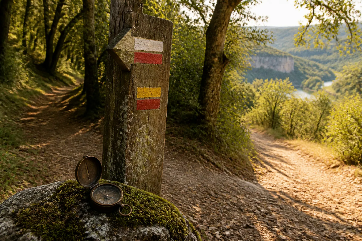
A marked trail can still involve a steep valley climb, a forestry track, a limestone gorge, a poorly signposted junction, or a section where mobile coverage disappears completely.
The common Dordogne hiking navigation mistakes are not usually dramatic. They are small interpretation errors. A red-and-white blaze is mistaken for a local yellow route. A smartphone route is trusted after the battery has dropped to 18%. A two-hour walk is started at midday in July, despite a route profile that gains most of its height in the first forty minutes. The landscape is attractive. The logistics remain indifferent.
Decoding the French trail marking system
French trail markers are standardised, but they are not self-explanatory to every visitor. The colour and pattern identify the route category. They do not indicate difficulty, shade, distance, or suitability for children.
The basic system is as follows:
| Route designation | Trail marking | What it usually indicates |
|---|---|---|
| GR | Two horizontal bars: red over white | A long-distance route crossing a wider region |
| GRP | Two horizontal bars: red over yellow | A regional long-distance route, often circular or linked to regional itineraries |
| PR | One yellow bar | A local walking route, normally shorter and managed at a local level |
| Wrong direction | Red cross or X | The marked direction is incorrect; return to the previous junction |
The distinction between route types matters when several paths share the same section. A village sign may list a PR loop while the path itself also carries GR or GRP markings. The route you intend to follow may not be the most visible one at the junction.
GR, GRP and PR are not difficulty ratings
A GR route can be technically straightforward but long. A PR route can be short but steep. A local loop around a bastide may include a sustained descent to a river and a sharper return climb through woodland. Route classification is administrative and navigational. It is not a substitute for a terrain assessment.
This is one of the more persistent hiking in Dordogne trail markers errors: treating the yellow PR marking as an assurance of gentle walking. It is not. The yellow bar tells you that you are following a local Promenade et Randonnée route. It says nothing about gradient, exposed rock, loose limestone, mud, or the number of kilometres remaining.
At each junction, identify three things before moving:
1. The route colour and pattern. Confirm that the mark corresponds with the walk selected on the local board, paper map, or GPX file.
2. The direction of travel. A mark on a tree behind you may be visible only after passing the junction. Do not assume that the first blaze seen ahead belongs to your route.
3. The next physical confirmation point. This may be a road, a bridge, a hamlet, a church, a forestry track, or a change in surface. If the expected feature does not appear within the estimated distance, stop and reassess.
The red cross is particularly useful. It does not necessarily mean the terrain becomes dangerous. It means that continuing in that direction conflicts with the marked route. Visitors who ignore it often do so because the wrong track looks more worn. In rural Dordogne, agricultural vehicles, forestry work, animals, and informal access can create paths that are more obvious than the official footpath.
A trail blaze confirms route direction. It does not confirm route difficulty, shade, surface condition, or mobile coverage.
Signposts have a narrow job
French walking signposts normally provide direction and destination information. They are not complete route descriptions. A sign indicating a nearby village does not tell you whether the path reaches it along a contour, by a direct descent, or over a ridge.
The same applies to local route boards. They can show a useful overview but may simplify the terrain profile. A loop drawn as a clean circle may contain several hundred metres of cumulative ascent and descent. In the Dordogne Valley, horizontal distance is a poor proxy for effort because the river corridor and surrounding plateaux are separated by abrupt slopes.
Treat every junction as a measurement problem:
- Which route marker should be visible?
- How far is the next confirmed feature?
- Is the path surface changing from paved lane to compacted track, or from track to rock?
- Does the map show a valley floor, contour line, or ridge crossing?
- Is the route entering private agricultural land or a forestry section?
That process takes less time than recovering from a wrong turn after an hour of walking.
The 1:25,000 reality: why paper maps still matter
For aquitaine hiking trail maps, the useful standard is the IGN topographical map at a 1:25,000 scale. At this scale, one centimetre on the map represents 250 metres on the ground. That is sufficient to show minor tracks, contour detail, buildings, watercourses, woodland, and many route features that disappear on a general tourist map.
The value is not nostalgia. It is redundancy.
A phone offers a moving position marker and, with the correct application, a GPX track. A paper map offers a stable view of the entire route, the surrounding alternatives, and the terrain beyond the official line. If the path is obstructed by timber work, flooding, livestock, or a damaged section, the paper map provides context for a diversion. A phone may only show that you are no longer on the intended track.
What the map tells you before departure
Read the map before leaving the gîte. Do not wait for the first ambiguous junction.
The useful information includes:
- Contour spacing. Closely spaced contour lines indicate a steeper slope. A route that appears short may be physically demanding if it crosses several contour intervals in a small horizontal distance.
- Valley geometry. A river crossing followed by a tight cluster of contours usually means a direct climb, not a gentle continuation.
- Surface and access. Minor roads, tracks, woodland routes, and built-up sections behave differently under heat, rain, and footfall.
- Alternative return lines. A loop with no viable exit can become a problem if the planned route is blocked.
- Water and settlement points. These are navigation references, not necessarily reliable resupply points. A mapped fountain or stream may not be potable or flowing.
- Scale and elapsed time. Calculate distance from the map rather than relying on a route name such as a village loop or river walk.
An IGN map will not remove every uncertainty. It cannot provide real-time information about a fallen tree, recent logging activity, or a temporary closure. Those conditions are among the local unknowns that need confirmation with the relevant commune or tourist office before departure.
Why a smartphone is a supplement, not a control system
Mobile navigation fails in predictable ways. Rural valleys and limestone gorges can have weak or absent signal. Wooded sections reduce visibility and make route interpretation harder. Heat accelerates battery drain. A fall can damage the screen or charging port. A phone used for photographs, navigation, and emergency communication is carrying several operational tasks on one battery.
Download maps and GPX files before leaving the property. Do not assume that a route page will load when you reach the trailhead. Carry the paper map in a protective sleeve, and keep the phone accessible but not exposed to direct sun for the entire walk.
The correct hierarchy is simple:
1. Route plan and terrain reading before departure.
2. Paper map for orientation and alternatives.
3. Waymarks and local signposts for ground confirmation.
4. Offline GPX track as a position check.
5. Mobile signal as a convenience, not a navigation guarantee.
A dedicated hiking app such as VisoRando can help with supplementary GPX information, but a digital track is still a line recorded under particular conditions. It may not reflect a new obstruction, an altered access arrangement, or the most comfortable direction around a steep section.
Limestone gorges and rural dead zones
The Dordogne’s river valleys create a specific navigation problem. The route may be visually obvious along the water, then become less obvious as it climbs through woodland and limestone terrain. The change in surface is often accompanied by a change in route logic.
At the valley floor, you may follow a towpath, minor road, riverside track, or broad recreational route. Above the river, the path can narrow, cross exposed roots, join a forestry road, or pass between agricultural parcels. The vertical distance is more significant than the map’s apparent route length.
The first climb is the controlling section
Many walks are judged by their total distance. That is inadequate around river bluffs and bastide villages. Record the first significant climb separately. A route of six or seven kilometres with a concentrated ascent may require more energy and better footwear than a longer route on a gradual surface.
The practical assessment is:
- Is the climb direct or contouring?
- Does the route surface change after the river section?
- Are there exposed limestone steps or loose stone?
- Is there shade during the ascent?
- Can the group turn back without creating a longer return?
- Will the descent take place during the hottest part of the day?
The last question is overlooked. A morning ascent may be manageable under shade, while the return descent is exposed and hotter. Route direction can therefore matter even on a circular trail.
Navigation without continuous signal
In a gorge or wooded valley, do not wait for the GPS position to become uncertain before checking the map. Use fixed references. Bridges, bends in the river, prominent buildings, power lines, road crossings, and changes in slope are more dependable than a fluctuating digital position.
A useful field procedure is to confirm the route at every major change in direction:
- Save the last known position while the phone still has a reliable signal.
- Note the next junction and the physical feature expected there.
- Walk to that feature using the visible blaze and terrain.
- Compare the map, route marking, and actual ground before continuing.
- If two of the three disagree, stop. Do not vote by instinct.
This is especially relevant where local walks cross logging roads. A forestry track may be broad, level, and apparently suitable, while the official route leaves it through an inconspicuous side entrance. The correct path may have lower footfall than the vehicle track.
Private land and agricultural crossings
Some self-guided routes cross or skirt agricultural fields and private land. A worn line across grass is not automatically a public footpath. Gates, stiles, and waymarks provide stronger evidence than a line visible in the ground.
Close gates after passing. Keep clear of working machinery and livestock. If a waymark appears to terminate at a field boundary, examine the boundary itself for a stile, gate, or continuation marker before crossing. Do not improvise a new route through crops because the GPX line appears to cut directly across them.
The Dordogne has a large number of marked paths, but the network is not a single engineered trail surface. It is a mixture of public lanes, tracks, woodland routes, field edges, and footpaths. Expect variation in construction and maintenance.
Timing your trek in the Périgord
The recommended summer start for a serious morning walk is around 06:30. That is not a lifestyle suggestion. It is a heat-management measure.
An early departure reduces exposure during the hottest period, improves the chance of walking shaded climbs before the sun reaches the valley slopes, and creates a margin if a junction requires investigation. It also makes it more likely that a longer route finishes before the most intense midday conditions.
The thermal behaviour of the landscape changes through the day. River mist may remain in lower sections during the early morning. Limestone and exposed tracks then absorb and radiate heat. Woodland provides shade but can restrict visibility and make damp surfaces slower underfoot. A forecast temperature taken at a town does not describe every section of a route.
Estimate time by terrain, not by kilometres
A flat two-kilometre stretch on a firm track and a two-kilometre climb over uneven limestone do not have the same time requirement. Group composition also affects the result. Children, older walkers, dogs, and anyone carrying a substantial day pack alter the pace and the frequency of stops.
Build the route around fixed limits:
- Set a turnaround time, not only a destination.
- Leave a reserve for navigation errors and unplanned rests.
- Keep water access separate from the assumption that a stream or fountain is usable.
- Avoid scheduling the most exposed climb immediately before the planned finish.
- Treat a route description’s walking time as an estimate, not a contractual duration.
A swimming pool at the gîte is a useful recovery asset, but it does not compensate for poor route timing. Poolside leisure belongs after the route has been planned around heat, shade, and descent exposure. The presence of a pool should not encourage an overlong walk in the expectation that discomfort can be resolved on return.
Seasonal access and hunting activity
The search phrase Dordogne walking routes hunting season reflects a genuine planning concern, but it should not be handled through assumptions about a single department-wide schedule. Restrictions, notices, and local activity can vary by commune, woodland, and time of year.
Before entering a rural or wooded route during an active hunting period, check local notices and ask the relevant tourist office, commune, or property manager whether a route is affected. Pay attention to temporary signs at trailheads and road crossings. Do not remove or ignore them because the route is shown on an older map.
The same approach applies after storms and during forestry operations. Exact closure information is local and can change faster than printed material. A marked route is not proof that every section is currently open.
The route length is a number. The route’s exposure, ascent profile, surface, and exit options determine whether that number is useful.
Integrating GPX data with local signage
GPX data is valuable when used for confirmation. It is unreliable when treated as a complete description of current ground conditions.
A recorded track can show that someone previously travelled through a location. It does not prove that the same line remains accessible, correctly marked, or comfortable for your group. GPS accuracy also varies under tree cover, beside rock faces, and in narrow valleys. A position line several metres from the path may be normal. A line on the opposite side of a river is not.
The three-layer navigation method
Use three independent layers:
The official marking. This is the physical route indication on the ground: GR, GRP, or PR. It should be the first confirmation.
The topographical map. This explains why the path is where it is. It shows the slope, road network, watercourses, and alternative routes.
The GPX track. This helps identify your current position and can expose a missed turn, provided the file was downloaded offline.
If all three agree, proceed. If the GPX line disagrees with the physical marking, examine the wider map before assuming the marking is wrong. The GPX file may represent a variant, an old line, or a recording error. If the map and ground agree against the phone, follow the physical evidence and investigate later.
Route planning from a Dordogne gîte
The property’s location changes the practical shape of a walking day. A gîte several kilometres from a trailhead may require a car, a narrow rural road approach, and parking at a village edge rather than beside the route. A route described as local may still involve a drive before the walking begins.
Before selecting a walk, record:
- Driving time from the gîte to the trailhead.
- Parking availability and whether it is inside a village or at an isolated roadside point.
- The first reliable navigation reference after leaving the vehicle.
- Whether the route returns to the same parking area.
- The distance between the walk and food, fuel, or water supplies.
- The time required to return before pool access, dinner reservations, or other fixed plans.
These are proximity metrics, not administrative details. A beautiful route that requires a late return on an unfamiliar rural road may be a poorer choice than a shorter circuit starting near the property.
The gîte itself can also provide useful local intelligence, but treat verbal directions as a supplement. Ask for the exact commune, parking location, route name, and any current access notices. A phrase such as “just over the hill” is not a usable distance measurement. Request the map reference or a shareable location.
A practical failure sequence to avoid
Most navigation failures follow a recognisable pattern:
1. The walker selects a route by its name or scenery. The ascent profile and surface are not examined.
2. The route is saved only online. No offline map, GPX file, or paper backup is prepared.
3. A junction contains several paths. The first visible track is followed without identifying the correct blaze.
4. The phone loses signal or battery. The position marker stops updating.
5. The group continues because the track looks plausible. Footfall is mistaken for official route confirmation.
6. The error is discovered late. Returning now adds distance and places the group in the hottest part of the day.
The correction is procedural rather than technological. Plan the terrain. Identify the route marking. Download the data. Carry an IGN map. Set a turnaround time. Stop at the first contradiction.
For a compact day route, the minimum useful equipment is not extensive:
- IGN 1:25,000 map covering the full route and return options.
- Offline route data or GPX file.
- Phone with sufficient charge and a protected screen.
- Water capacity matched to the heat and route duration.
- Footwear suitable for loose stone, damp woodland, and uneven descents.
- A basic first-aid kit.
- A written property address and emergency contact details, especially where signal is intermittent.
The value test
Dordogne hiking trails navigation mistakes are rarely caused by a lack of available paths. The department has an unusually extensive network. The problem is that the network crosses terrain that changes faster than the brochure language suggests.
Read the route category correctly. Use the red-and-white, red-and-yellow, and yellow markings as directional systems, not difficulty ratings. Carry the 1:25,000 map because valleys and batteries both fail at inconvenient moments. Treat GPX as corroboration. Start early in summer. Measure the climb, the exposure, the drive to the trailhead, and the return margin.
The binary verdict is straightforward: a Dordogne walk is good value when the route’s physical demands match the time, equipment, and navigation method available. If those variables are unknown, the walk is not yet planned. It is only advertised.