Hiking trails or mountain biking paths: choosing your terrain
The first hazard is not the climb. It is choosing a route that does not match your movement, equipment, or legal access.
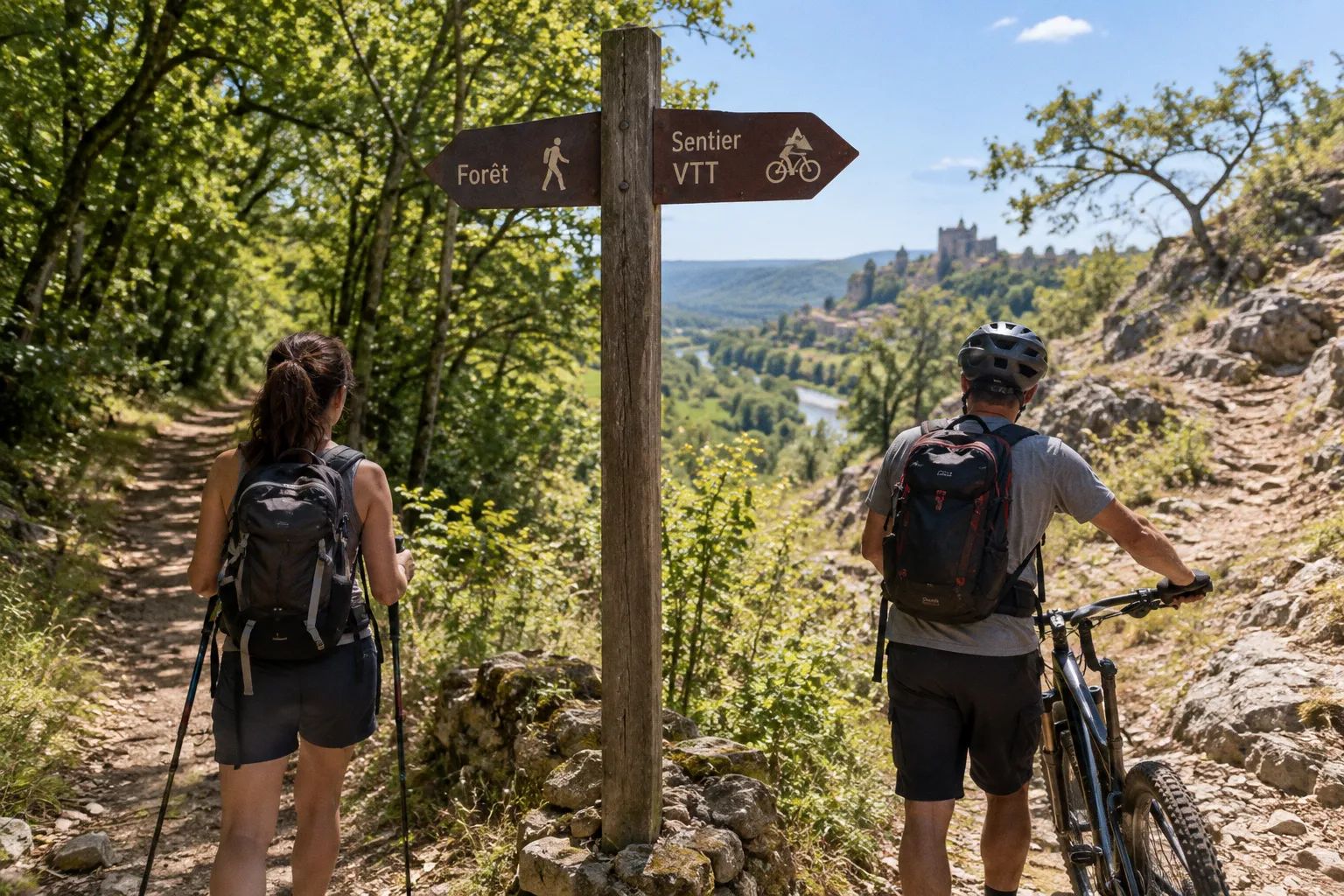
In the Dordogne, a trail that works perfectly on foot can become a poor mountain-bike line within minutes: narrow forest sections, loose surfaces, steep braking zones, gates, and shared-use traffic all change the tactical picture.
The decision between hiking trails and mountain biking paths in Dordogne comes down to four variables: terrain width, technical difficulty, elevation, and route access. The region offers more than 1,000 km of marked mountain-bike trails, alongside long-distance walking routes, greenways, river corridors, and multi-use tracks. That gives you range. It also gives you more ways to select the wrong deployment.
Use the route network as a map of friction points, not as a catalogue of attractive names. Select the activity first. Then select the surface, grade, distance, and return strategy.
Start with access: a marked trail is not an open invitation
The legal position is straightforward enough to matter before you leave the gîte. In French public forests, mountain biking is restricted to marked trails and forest paths more than 2.5 metres wide on heavily frequented routes under the relevant Forestry Code rules. Riding off the authorised path can result in fines of up to €1,500.
That immediately separates hiking and mountain biking planning. A walker can often negotiate a narrow footpath at a controlled pace, provided the route is open to pedestrians and no local restriction applies. A rider needs more than a visible line through the trees. The track must be legally available, physically rideable, and wide enough for the conditions and traffic.
Do not interpret this as a blanket rule that every narrow forest trail is forbidden to bicycles. Local signage, route marking, land management, and municipal restrictions govern the individual section. The correct procedure is to confirm the route designation before loading the bike, particularly where a planned ride crosses public forest, protected land, or a network of shared paths.
Three access situations require different preparation:
- Shared greenways and public tracks: generally the most straightforward option for combining walking and cycling. Expect pedestrians, families, changing surface quality, and a slower current flow.
- Marked VTT routes: designed for mountain biking and classified by difficulty. The colour system runs from green through blue and red to black.
- Narrow walking routes and long-distance footpaths: useful for hiking, but not automatically suitable or authorised for cycling along every section. Local exceptions and signage can change the position.
The route marking is your first waypoint. If the access status is unclear, the route is not ready for deployment.
A cycling route also needs a return plan. Out-and-back rides can become inefficient when the outbound section is fast and the return section faces a headwind, steep ascent, or technical fatigue. A hiking route has the same problem in a different form: a comfortable descent at kilometre five may become a slow, exposed withdrawal at kilometre fifteen.
Decode the difficulty system before you commit
French VTT routes use four colour levels:
| Trail colour | Operational meaning | Best suited to |
|---|---|---|
| Green | Easier terrain with lower technical demand | Beginners, families, short training rides |
| Blue | Moderate route requiring basic control and fitness | Confident recreational riders |
| Red | More demanding terrain, steeper sections, or technical obstacles | Experienced riders with a reliable gear loadout |
| Black | High technical and physical commitment | Advanced riders prepared for difficult terrain |
The colour is not a replacement for route intelligence. It gives you an initial difficulty signal, not a full forecast of the day. A blue route can still expose a rider to heat, accumulated ascent, loose descents, or a long distance from the nearest road. A green route can become more difficult when wet, congested, or approached with unsuitable tyres.
For hikers, route grading is often less uniform across the wider network. Distance and elevation gain become the core controls. A route of 10 km with repeated short climbs can demand more than a longer path that follows a valley floor. Surface matters as well: compact tracks allow a faster walking rhythm, while roots, stones, mud, and irregular steps break the stride and increase load on the ankles.
When comparing hiking trails vs mountain biking paths in Dordogne, do not compare distance alone. Compare the number of decisions required per kilometre.
A cyclist must constantly manage:
1. Line choice: selecting the safest wheel path through stones, ruts, roots, and surface changes.
2. Braking: controlling speed before the descent or obstacle, not during the last metre.
3. Body position: shifting weight through climbs, drops, and loose corners.
4. Mechanical exposure: managing punctures, chain issues, brake wear, and equipment failure.
5. Traffic awareness: yielding and adjusting speed on shared paths.
A hiker manages a different sequence:
1. Pacing: holding a sustainable ascent rhythm rather than burning energy early.
2. Foot placement: reading uneven ground before committing weight.
3. Weather exposure: staying ahead of heat, rain, and slippery descents.
4. Navigation: maintaining the correct waymark when paths divide or enter settlements.
5. Return timing: protecting enough energy for the final section, not just reaching the halfway point.
The rider covers more ground per hour only when the terrain allows it. On technical or heavily shared routes, the speed advantage can narrow sharply. The hiker moves more slowly but can access sections where a bicycle becomes a liability.
Shared paths: the most flexible option, not always the most exciting
The Dordogne includes several long shared corridors that work well for mixed groups. The Voie Verte of the Céou Valley runs for 25 km between Castelnaud-la-Chapelle and L’Abbaye-Nouvelle in Lot. It is suitable for walking and cycling, making it a practical choice when one person wants to ride and another wants to walk.
The Voie Verte des Berges de l’Isle provides a 100 km shared path through Périgueux and beyond. Its length creates multiple planning options: a short family section, a longer training segment, or a point-to-point day with transport arranged at the far end.
These routes reduce some of the route-finding friction. They do not remove the requirement for discipline. Shared paths carry pedestrians and cyclists in the same operating space. Blind bends, junctions, dogs, children, and changing surfaces require controlled speed. A cyclist treating a greenway as a race corridor creates risk without gaining meaningful route time.
For a mixed-ability group, shared paths are often the strongest decision because they allow the party to remain together. But the group still needs a distance limit. A 25 km corridor does not mean the full 25 km is the right mission for a first day. A 100 km route does not need to be attacked as one continuous objective.
Use shared paths when:
- your group includes both walkers and cyclists;
- you need predictable navigation;
- the priority is conversation, river access, villages, or a steady training effort;
- you want an easier abort point near roads or settlements;
- the weather forecast is uncertain and a flexible return matters.
Avoid treating them as a substitute for technical mountain-bike terrain. The surface may be easier, but the route can still become physically demanding over distance. Equally, walkers looking for steep woodland, rock, and elevation shifts may find a greenway too controlled.
A shared path is a logistics advantage. It is not automatically a terrain challenge.
Hiking gives you access to the narrow line
Walking is the better tool when the route objective is terrain immersion rather than distance covered. Foot travel lets you slow down at steep gradients, negotiate narrow ground, and move through sections where a bicycle would need to be pushed or carried. It also gives the group more control over stops, navigation checks, and changes in weather.
The Chemin d’Amadour is a 500 km long-distance walking route divided into 21 stages ranging from 11 km to 32 km per day. That range demonstrates the correct way to read a long-distance trail: stage distance is a planning framework, not a compulsory daily target. A 11 km stage may suit a shorter active day, while a 32 km stage demands a stronger endurance base and a precise food and water plan.
Do not import the full stage distance into a casual day automatically. Use a section of the route, establish a turnaround waypoint, and protect the return window. Long-distance trails pass through changing terrain and settlements. The line on the map may be continuous; your energy supply is not.
Hiking is usually the stronger choice when:
- the route has narrow or irregular sections;
- the main objective is a sustained ascent, viewpoint, village approach, or historical route;
- the group has mixed cycling ability but similar walking pace;
- the weather requires frequent pauses and route reassessment;
- carrying a bike would add more friction than value;
- you want to minimise mechanical dependency.
The trade-off is obvious. Walking compresses more of the day into movement at ground level. A route that looks short on a map can consume a full half-day once ascent, heat, pauses, and navigation are included. Plan the descent with the same seriousness as the climb. Fatigue changes foot placement and concentration before it changes your declared pace.
Mountain biking covers the valley faster—but punishes poor route selection
The Dordogne’s marked VTT network gives riders a broad range of options, from green and blue routes to red and black terrain. This is where mountain biking becomes more than a faster version of hiking. The bicycle changes how you interact with the landscape. You can link villages and forest sections over a greater distance, build a route around a valley corridor, and use short climbs as repeated training efforts.
It also increases the consequences of poor preparation.
The primary load is not only the bike. It is the rider’s ability to maintain control after the legs begin to fade. A route with several short ascents can feel manageable in the opening section, then become difficult when every descent requires braking and every corner demands a line decision. A technically rated route should be selected according to current handling ability, not aspirational fitness.
For riders choosing between mountain biking routes in the Dordogne Valley, classify the day by its dominant demand:
- Endurance route: longer distance, moderate technical demand, sustained output.
- Climbing route: repeated elevation shifts and a high demand on pacing.
- Technical route: obstacles, loose surfaces, steep entries, and greater handling risk.
- Exploration route: variable surfaces, navigation decisions, and uncertain timing.
Do not combine all four on a first outing. A long technical route with major climbing is a separate operation from a steady greenway ride. The gear, food, timing, and recovery plan must match the most demanding feature, not the easiest opening kilometres.
Cycling is the right deployment when:
- the route is clearly marked for VTT use;
- the group can maintain safe spacing and controlled speed;
- the bicycle is correctly fitted and mechanically sound;
- the objective is to link several locations rather than remain on one short section;
- the riders understand the colour grading and accept the return distance;
- the route provides realistic alternatives if a section becomes unrideable.
The final point matters. A rider must be ready to dismount. Walking a short obstacle is not failure; it is correct terrain management. Forcing a line to preserve momentum can damage the bike, the rider, or both.
The serious test: Dordogne de Villages en Barrages
The Dordogne de Villages en Barrages route is a major endurance objective: 200 km along five hydroelectric dams, with a cumulative elevation gain of 8,000 metres. It is designed for experienced hikers and mountain bikers.
This is not a casual scenic loop. The elevation figure changes the entire planning model. At 8,000 metres of cumulative ascent, the route becomes a sustained fatigue operation whether completed on foot, by bike, or in stages. The distance is substantial. The repeated climbs are the control point. The route demands a realistic stage plan, resupply strategy, weather tolerance, and recovery schedule.
For hikers, the route requires disciplined stage selection. Even if the total route is divided into manageable days, the cumulative ascent can produce delayed fatigue. A strong first stage does not prove that the second stage is correctly loaded. Keep the opening pace below maximum. The objective is not to win the first climb; it is to preserve stable movement across the full itinerary.
For mountain bikers, the ascent creates a different problem. The bicycle improves travel speed on suitable sections, but it also adds equipment, mechanical exposure, and technical consequences on descents. The route may include sections where the rider must push, carry, or stop to protect the bike and body. A fast average on the early valley section can become irrelevant if the rider arrives at the major climbs depleted.
Use this route as a benchmark for honest route selection:
| Question | Hiking response | Mountain-bike response |
|---|---|---|
| Can the group sustain repeated climbs? | Set a conservative walking pace and reduce stage length if required | Control cadence and preserve braking and handling strength |
| What happens if the surface becomes technical? | Slow down, reassess footing, and continue on foot | Dismount early rather than force an unstable line |
| How does distance affect the day? | Walking time expands quickly with ascent and heat | Speed advantage varies sharply by terrain and traffic |
| What is the main equipment risk? | Footwear failure, inadequate layers, water or food shortage | Puncture, brake or drivetrain issue, plus rider fatigue |
| What is the withdrawal plan? | Identify road access and settlement waypoints | Identify transport options and mechanical recovery points |
The route is an excellent target for experienced visitors who want a serious active holiday. It is the wrong target for a group that has not yet established its pace, equipment, or navigation habits in the Dordogne.
Scenic walking paths versus cycling tracks: choose the experience you can control
The best terrain for Dordogne hiking is not always the terrain with the greatest distance or the highest viewpoint. It is the terrain where your group can keep moving without turning every kilometre into a negotiation.
Walking favours close control. You can stop at a junction, inspect a muddy section, adjust layers, and resume without the preparation required to secure and restart a bicycle. This makes hiking resilient when the day is variable. It also suits groups that want to combine outdoor movement with village stops, food, and local exploration.
Cycling favours range. A marked route can connect more of the valley in a single outing, particularly on shared paths and suitable tracks. This makes the bicycle effective for active travellers who want to reach several waypoints before returning to the gîte and pool. The risk is overextension. More range often creates the illusion that more range should be used.
Build the decision around the weakest operational point in the group:
- If one person lacks bike-handling confidence, choose an easier cycling route or switch to walking.
- If one person cannot sustain the planned walking distance, choose a shorter loop with a firm turnaround.
- If equipment is limited, use a lower-risk shared path rather than a technical route.
- If the weather is unstable, favour a route with clear exit points and simple navigation.
- If the group wants scenery with minimal physical commitment, use a short greenway or village-linked walk rather than disguising a leisure outing as an endurance mission.
- If the group wants training value, select the surface and elevation first, then add distance.
This is where a poolside recovery plan becomes useful. A stay with a private pool can support a split day: an early walk or ride before the heat builds, then recovery without adding another transfer. But do not use the pool as an excuse to overload the route. Recovery improves the next outing; it does not erase poor pacing on the current one.
Route planning: build the day in chronological order
A reliable Dordogne outdoor activity plan begins before the trailhead. Work through the route in the order the terrain will attack you.
1. Confirm the access status
Check whether the line is marked for hiking, VTT, or shared use. Look for local signs at forest entries, junctions, and route transitions. Do not assume that one legal section authorises the next one.
2. Locate the first irreversible commitment
This may be the first major ascent, a remote forest section, or the point where the route leaves a road corridor. Set a time and energy limit before reaching it. If the group is already struggling, turn back while the return remains simple.
3. Load the route by elevation, not just kilometres
Record the major climbs and descents. On foot, the ascent controls pace. On a bike, the combination of ascent and technical descent controls fatigue. A route with modest total distance can still demand a full physical effort if the elevation shifts are repeated.
4. Establish waypoints
Use villages, junctions, bridges, road crossings, and clear route markers. Every waypoint should answer one question: continue, turn back, or exit. A vague midpoint is not a useful control point.
5. Set the turnaround
Do not wait until the group feels tired. Set the turnaround based on time, weather, daylight, and remaining energy. The return leg is part of the route, not an optional extension.
6. Protect the final descent
Descending is not free movement. Hikers face unstable footing and reduced concentration. Cyclists face speed, braking, and surface hazards. Keep the final section controlled. The last kilometres are where an overloaded plan exposes itself.
This process works across the region, whether you are selecting a section of the Chemin d’Amadour, a Céou Valley greenway ride, a route near the Isle corridor, or a demanding multi-day objective.
Gear loadout: prepare for the actual surface
The correct loadout depends on the activity, but both groups need the same fundamentals: water, weather protection, navigation, and a recovery margin.
Hiking loadout
- Supportive footwear with a sole suited to uneven or loose ground.
- Water capacity matched to route length, heat, and access to resupply.
- A lightweight outer layer for rain or wind shifts.
- Food that can be used without stopping for a full meal.
- Charged phone with the route available offline where possible.
- Small first-aid kit and blister protection.
- Head protection from sun and a layer for cooler return conditions.
- A route note showing the next waypoint and the planned turnaround.
Do not carry a heavy pack because the route description sounds serious. Carry the items that keep the movement stable and the withdrawal possible.
Mountain-bike loadout
- Helmet correctly fitted before the first descent.
- Spare tube or puncture solution compatible with the bicycle.
- Pump or inflation system.
- Basic multi-tool and a method for dealing with a loose chain or adjustment issue.
- Water and food secured so they remain accessible without stopping in an unsafe position.
- Gloves for grip and hand protection.
- Eye protection where dust, branches, or flying debris may be present.
- Charged phone and route navigation.
- A layer that can be carried without interfering with control.
- Lights if the route timing could extend beyond full daylight.
The bike itself needs a pre-departure check: tyre condition, brake response, drivetrain operation, saddle security, and wheel attachment. A route is not ready because the rental bike rolls out of the courtyard.
Shared requirements
Carry identification, know the nearest road access, and tell someone the route intention when heading into a remote section. Keep the loadout compact. Excess weight becomes a direct penalty on every ascent, whether carried on your back or added to the bike.
The final decision
Choose hiking when narrow access, terrain reading, flexible pacing, and close-range exploration lead the day. Choose mountain biking when the route is legally marked, the surface supports safe riding, and the group can manage the technical and mechanical demands. Choose a shared greenway when logistics, mixed abilities, or a steady valley traverse matter more than technical challenge.
The best terrain for Dordogne hiking is the terrain your group can complete with control. The best mountain biking route in the Dordogne Valley is not the most aggressive colour on the map. It is the one that matches current handling, elevation tolerance, equipment, and return capacity.
Before deployment, run the final gear check:
- Route access confirmed.
- Trail colour or walking difficulty understood.
- Distance and cumulative ascent accepted by the whole group.
- Turnaround waypoint fixed.
- Weather and return timing checked.
- Water, food, layers, navigation, and first aid packed.
- Bike brakes, tyres, drivetrain, and repair kit checked.
- Exit route identified.
- No off-trail riding planned.
Then move. Select the correct surface, hold the pace, respect the markings, and keep enough capacity for the return. That is how you turn the Dordogne trail network into an active holiday rather than an avoidable recovery operation.